Content
-
class
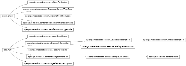
opengis.metadata.content.AttributeGroup -
property
attribute
-
abstract property
content_type Type of information represented by the value.
-
property
-
class
opengis.metadata.content.Band Range of wavelengths in the electromagnetic spectrum.
-
property
band_boundary_definition Designation of criterion for defining maximum and minimum wavelengths for a spectral band.
-
property
bound_max
-
property
bound_min
-
property
bound_units
-
property
detected_polarisation Polarisation of the transmitter or detector.
-
property
peak_response Wavelength at which the response is the highest.
-
property
tone_gradation Number of discrete numerical values in the grid data.
-
property
transmitted_polarisation Polarisation of the transmitter or detector.
-
property
-
class
opengis.metadata.content.BandDefinition An enumeration.
-
EQUIVALENT_WIDTH= 'equivalentWidth'
-
FIFTY_PERCENT= 'fiftyPercent'
-
HALF_MAXIMUM= 'halfMaximum'
-
ONE_OVER_E= 'oneOverE'
-
THREE_DB= '3dB'
-
-
class
opengis.metadata.content.ContentInformation Description of the content of a resource.
-
class
opengis.metadata.content.CoverageContentTypeCode An enumeration.
-
AUXILLARY_INFORMATION= 'auxillaryInformation'
-
COORDINATE= 'coordinate'
-
IMAGE= 'image'
-
MODEL_RESULT= 'modelResult'
-
PHYSICAL_MEASUREMENT= 'physicalMeasurement'
-
QUALITY_INFORMATION= 'qualityInformation'
-
REFERENCE_INFORMATION= 'referenceInformation'
-
THEMATIC_CLASSIFICATION= 'thematicClassification'
-
-
class
opengis.metadata.content.CoverageDescription Details about the content of a resource.
-
abstract property
attribute_description Description of the attribute described by the measurement value.
-
property
attribute_group
-
property
processing_level_code Code and codespace that identifies the level of processing that has been applied to the resource.
-
property
range_element_description
-
abstract property
-
class
opengis.metadata.content.FeatureCatalogueDescription Information identifying the feature catalogue or the conceptual schema.
-
property
compliance_code Indication of whether or not the cited feature catalogue complies with ISO 19110.
-
property
feature_catalogue_citation Complete bibliographic reference to one or more external feature catalogues.
-
property
feature_types Subset of feature types from cited feature catalogue occurring in dataset.
-
property
included_with_dataset Indication of whether or not the feature catalogue is included with the resource.
-
property
locale Language(s) used within the catalogue.
-
property
-
class
opengis.metadata.content.FeatureTypeInfo -
property
feature_instance_count
-
abstract property
feature_type_name
-
property
-
class
opengis.metadata.content.ImageDescription Information about an image’s suitability for use.
-
property
camera_calibration_information_availability Indication of whether or not constants are available which allow for camera calibration corrections.
-
property
cloud_cover_percentage Area of the dataset obscured by clouds, expressed as a percentage of the spatial extent.
-
property
compression_generation_quantity Count of the number of lossy compression cycles performed on the image.
-
property
film_distortion_information_availability Indication of whether or not Calibration Reseau information is available.
-
property
illumination_azimuth_angle Illumination azimuth measured in degrees clockwise from true north at the time the image is taken. For images from a scanning device, refer to the centre pixel of the image.
-
property
illumination_elevation_angle Illumination elevation measured in degrees clockwise from the target plane at intersection of the optical line of sight with the Earth’s surface. For images from a scanning device, refer to the centre pixel of the image.
-
property
image_quality_code Code in producers code space that specifies the image quality.
-
property
imaging_condition Conditions affected the image.
-
property
lens_distortion_information_availability Indication of whether or not lens aberration correction information is available.
-
property
radiometric_calibration_data_availability Indication of whether or not the radiometric calibration information for generating the radiometrically calibrated standard data product is available.
-
property
triangulation_indicator Indication of whether or not triangulation has been performed upon the image.
-
property
-
class
opengis.metadata.content.ImagingConditionCode An enumeration.
-
BLURRED_IMAGE= 'blurredImage'
-
CLOUD= 'cloud'
-
DEGRADING_OBLIQUITY= 'degradingObliquity'
-
FOG= 'fog'
-
HEAVY_SMOKE_OR_DUST= 'heavySmokeOrDust'
-
NIGHT= 'night'
-
RAIN= 'rain'
-
SEMI_DARKNESS= 'semiDarkness'
-
SHADOW= 'shadow'
-
SNOW= 'snow'
-
TERRAIN_MASKING= 'terrainMasking'
-
-
class
opengis.metadata.content.PolarisationOrientationCode An enumeration.
-
HORIZONTAL= 'horizontal'
-
LEFT_CIRCULAR= 'leftCircular'
-
PHI= 'phi'
-
RIGHT_CIRCULAR= 'rightCircular'
-
THETA= 'theta'
-
VERTICAL= 'vertical'
-
-
class
opengis.metadata.content.RangeDimension Information on the range of attribute values.
-
property
description Description of the range of a cell measurement value.
-
property
name Identifiers for each attribute included in the resource. These identifiers can be used to provide names for the resource’s attribute from a standard set of names.
-
property
sequence_identifier Number that uniquely identifies instances of bands of wavelengths on which a sensor operates.
-
property
-
class
opengis.metadata.content.RangeElementDescription Description of specific range elements.
-
abstract property
definition Description of a set of specific range elements.
-
abstract property
name Designation associated with a set of range elements.
-
abstract property
range_element Specific range elements, i.e. range elements associated with a name and definition defining their meaning.
-
abstract property
-
class
opengis.metadata.content.SampleDimension The characteristics of each dimension (layer) included in the resource.
-
property
bits_per_value Maximum number of significant bits in the uncompressed representation for the value in each band of each pixel.
-
property
max_value Maximum value of data values in each dimension included in the resource. Restricted to UomLength in the MD_Band class.
-
property
mean_value Mean value of data values in each dimension included in the resource.
-
property
min_value Minimum value of data values in each dimension included in the resource. Restricted to UomLength in the MD_Band class.
-
property
nominal_spatial_resolution
-
property
number_of_values This gives the number of values used in a thematicClassification resource EX:. the number of classes in a Land Cover Type coverage or the number of cells with data in other types of coverages.
-
property
offset The physical value corresponding to a cell value of zero.
-
property
other_property Instance of otherAttributeType that defines attributes not explicitly included in MD_CoverageType.
-
property
other_property_type Type of other attribute description (i.e. netcdf/variable in ncml.xsd).
-
property
scale_factor Scale factor which has been applied to the cell value.
-
property
standard_deviation Standard deviation of data values in each dimension included in the resource.
-
property
transfer_function_type
-
property
units Units of data in each dimension included in the resource. Note that the type of this is UnitOfMeasure and that it is restricted to UomLength in the MD_Band class.
-
property
-
class
opengis.metadata.content.TransferFunctionTypeCode An enumeration.
-
EXPONENTIAL= 'exponential'
-
LINEAR= 'linear'
-
LOGARITHMIC= 'logarithmic'
-


